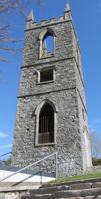
Who Rubbed Out Helena’s Life In Royal Hillsborough?
Helena Roberts has been found dead in Royal Hillsborough. With a heavy case load our chief detective needs your help to solve this murder mystery. Although Helena’s body was found in the lake the coroner has ruled out drowning. So how did she get here? Was her body dumped to throw us off the scent? Only by following the evidence trail will all be revealed!
 This is a self-guided walking Whodunit Hunt in Royal Hillsborough, County Down.
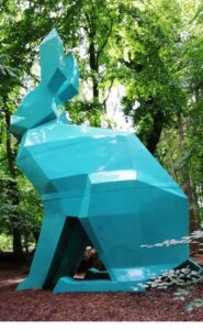
- On your clue hunt you’ll see historic buildings, strange creatures in the forest, the village’s fort and beautiful lake nearby. Also learn about the history of Hillsborough, spanning hundreds of years, and characters that shaped it! We’ll tell you about ghosts haunting Hillsbrough Castle too!
- The clue route is 2 ¼ miles / 3 ½ km. Allow at least two hours to solve this case.
- Accessibility – there are some slopes, primarily the hill in Royal Hillsborough.
- There are assorted places for refreshment, including delicious sweet treats on Lisburn Street!
To purchase this Whodunit Hunt with credit / debit / Amex card please click here.
To pay using Paypal click here (or in the menu) to order this, or any other, Whodunit Hunt.
The starting point is shown in the map below.

(c) 2023 – the term ‘Whodunit Hunt’, associated logo, website content, and all Hunt routes, ideas, images and photos, are protected by copyright. Any copying/distribution of anything embraced by our copyright is intellectual theft and therefore unlawful and illegal. Please respect the law as well as numerous years of our hard work.
Short On Time? Try A Taster Trail!
 Ever thought of trying a Whodunit Hunt but always short on time or weren’t sure how much you’d enjoy it? Or wondered if you’d be ‘good enough’ to solve a case (which really doesn’t matter)? Then try one of our new taster trails! We’ve specifically designed them to take around 90 minutes to complete with walking routes of less than a mile. We’ll give you help with two clues if you get stuck.
We’ve launched two walking taster trails, our Europa Trail in Belfast and the Newry Taster Trail. There’s still 17-18 clues to solve (rather less than the 30+ clues in our standard length trails in these cities) but you’ll still get to see interesting places, learn about historic sites and notable people from these areas, and discover something new!
We’ve recently launched our first driving taster trails too – the Torr Road Taster Trail which starts at the quaint village of Cushendun and the Harry Ferguson Trail which follows in the footsteps of the famous inventor.
So try one of these taster trails and see if you’d like more of our kind of fun… definitely something different to do, for sure! They are at a bargain price of only £3.99!!
(c) 2023 – the term ‘Whodunit Hunt’, associated logo, website content, and all Whodunit Hunt routes, ideas, photos, are all protected by copyright. Any copying, impersonation or distribution of anything embraced by our copyright is intellectual theft and therefore unlawful and illegal. Please respect the law as well as all of our hard work.
Who Annihilated Ned In Newry?
Ned Black has alas been found murdered outside Café Krem on Hill Street but evidence suggests this was not where the murder was committed. Your help is needed to wrap up the case.
 This is a self-guided, walking murder mystery ‘taster trail’ in Newry, for if you’re short on time or want to try a mini Whodunit Hunt to see if you’ll like them. We hope you do!
- Did you know that Newry has a history stretching back around 1,000 years! It’s certainly not all about shops, and on this mini trail you’ll visit several historic stops, the canal, beautiful Newry Cathedral, and find out about several people remembered en-route as well as tragic maritime disasters.
- This may be a mini murder mystery but is still packed with 17 clues to solve. Despite sharing some of the route of our standard trail, we’ve come up with lots of different clues for this taster trail! It costs only £3.99!
- Allow 60-90 minutes to solve the clues.
- Accessibility – this is a totally flat route of less than a mile with no steps.
To purchase this Whodunit Hunt with credit / debit / Amex card please click here.
To pay using Paypal click here (or in the menu) to order this, or any other, Whodunit Hunt.
The clue hunt starts at the Market Place, shown below:
(c) 2023 – the term ‘Whodunit Hunt’, associated logo, website content, and all Hunt routes, ideas, images and photos, are protected by copyright. Any copying/distribution of anything embraced by our copyright is intellectual theft and therefore unlawful and illegal. Please respect the law as well as numerous years of our hard work.
Who Killed Kerry At Derrymore?
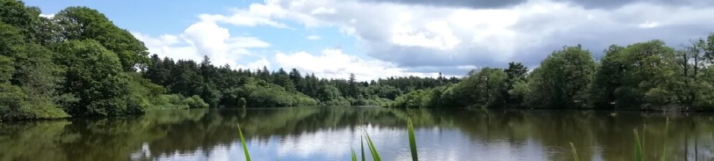
Kerry Moore has been found murdered in Derrymore House estate and, with our big case load, we need your help to solve the murder. Although Kerry’s body was found at the entrance to the house, the absence of blood around the body suggests this was not where the murder was committed and she may have even been murdered beyond the estate walls!
 The Derrymore Whodunit Hunt is a self-guided, walking murder mystery trail.
- Derrymore Estate near Newry is a lovely spot for woodland walks in landscaped grounds with a view of the Mournes, but it’s also rich in history with an elegant old cottage, a Quaker Meeting House, an old rath, and attractive gate lodges. In spring and summer the flowers are lovely!
- This murder mystery is jam packed with over 30 clues to solve in a booklet containing several pieces of extra historical information about the estate and nearby Bessbrook.
- The clue route is 1.9 miles, or about 3 km. The recommended time for completing it, excluding refreshment stops, is about two hours.
- Accessibility – the route has no steps and paths generally are either flat or with moderate inclines.

To purchase this Whodunit Hunt with credit / debit / Amex card please click here.
To pay using Paypal click here (or in the menu) to order this, or any other, Whodunit Hunt.
The trail of clues is confined to the Derrymore Estate, which is shown in the map below. Access to the estate, and parking at it, are free.
(c) 2023 – the term ‘Whodunit Hunt’, associated logo, website content, and all Hunt routes, ideas, images and photos, are protected by copyright. Any copying/distribution of anything embraced by our copyright is intellectual theft and therefore unlawful and illegal. Please respect the law as well as numerous years of our hard work.
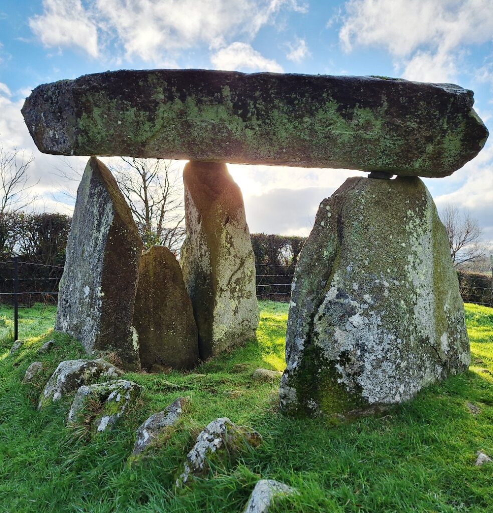 Ballykeel dolmen dates back around 5,500 years to 3,500 BC! It’s a great example of a tripod dolmen (or portal tomb) and is of the same type as the Legananny Dolmen (that can be seen on our Slieve Croob Whodunit Hunt in County Down) which is only a mile or two from Slieve Croob mountain.
Ballykeel Dolmen was only excavated in 1965 and had to be partially re-erected during excavations in 1965 that had begun two years earlier because the large capstone on top had fallen. Those investigations indicated that the tomb had been previously disturbed and, likely, some items taken – however, it still unearthed three highly decorated ‘Ballyalton’ bowls, hundreds of shards of pottery and some flint tools including a javelin head. High levels of phosphates found on the chamber floor confirm it was used for ancient burials.
This dolmen was at the southern end of a large cairn that measured approximately 10 * 30 metres. Most of this cairn has, with age, unsurprisingly disappeared but two parallel lines of stones can still clearly be seen. When it was originally built it would have had the appearance of that shown in the reconstruction photo below:
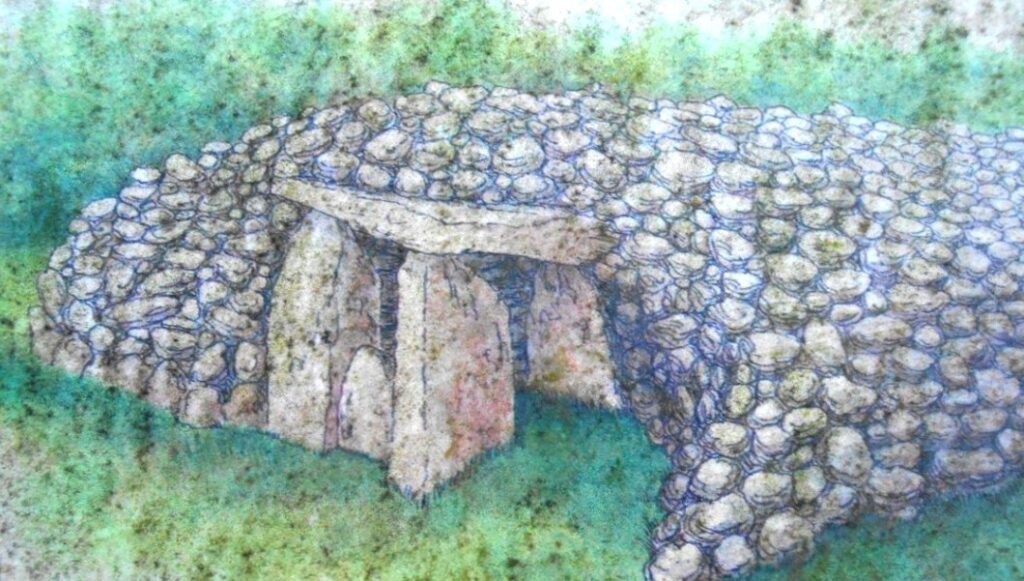
Known locally as ‘The Hag’s Chair’, the cairn is associated with the Cailleach, the mythical goddess of Winter. Legend has it that she would fly down from her home on Slieve Gullion to sit on the dolmen at Ballykeel, which served as her throne. Sacred rituals and ceremonies were likely performed here in ancient times.
(c) 2023 – the term ‘Whodunit Hunt’, associated logo, website content, and all Hunt routes, ideas, photos, are all protected by copyright. Any copying, impersonation or distribution of anything embraced by our copyright is intellectual theft and therefore unlawful and illegal. Please respect the law as well as all of our hard work.
Who Decimated Dolly in Dromore?
Dolly Moore has been found murdered in the historic market town Dromore and our best team of investigators are struggling to conclude the case and thus need your help to solve the murder.
 The Dromore Whodunit Hunt is a self-guided, walking murder mystery trail.
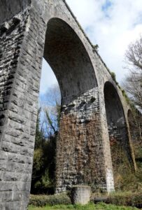
- Learn about the surprising amount of history that this former market town has to offer, which dates back over 800 years! You’ll learn about its railway history and see the impressive railway viaduct up close, read about famous inventor Harry Ferguson who was born nearby, see the cathedral and remains of an ancient Irish cross… and much more.
- The route is a moderate 1 ¾ miles, or about 2 ¾ km.
- The recommended time for this murder mystery, excluding refreshment stops, is around two hours.
- Accessibility – this is a mostly quite flat route, with just 2-3 steps to one clue.
- Refreshments – there are restaurants, cafes, and convenience stores along the clue trail.
To pay using Paypal click here (or in the menu) to order this, or any other, Whodunit Hunt.
To purchase this Whodunit Hunt with credit / debit / Amex card please click here.
The hunt for clues starts/ends at Dromore Park, shown below:
(c) 2023 – the term ‘Whodunit Hunt’, associated logo, website content, and all Hunt routes, ideas, images and photos, are protected by copyright. Any copying/distribution of anything embraced by our copyright is intellectual theft and therefore unlawful and illegal. Please respect the law as well as numerous years of our hard work.
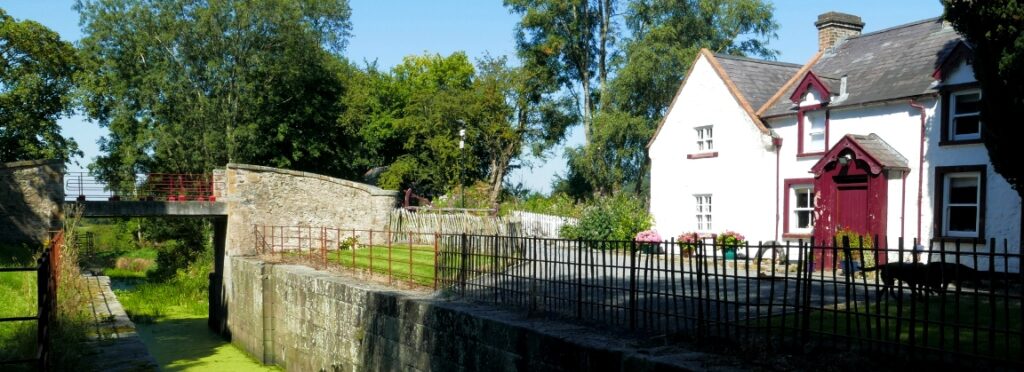
Who Murdered Tanya Magee From Tandragee?
Shy Tanya Magee from Tandragee was never one to steal the limelight… but having been found brutally murdered her name is big local news. Her body was found in the Newry Canal near Tandragee, but the initial post mortem ruled out drowning so foul play is suspected. The clue trail starts on the outskirts of Newry, where her best friend lives.
 The Newry Canal Trail murder mystery is a self-guided, driving Whodunit Hunt. It starts at Newry and ends near Gilford.
- The route progresses along and across the Newry canal until reaching Gilford, and some clues are beside its waters. En route you’ll visit several villages dating back hundreds of years and find out about some characters in their history. In Gilford you’ll see the remains of a magnificent mill and find out about the history of the linen industry in the area.
- The clue route is only 25 miles, or about 40 km! There is generally moderate walking, approximately 2 ½ miles / 4 km in total.
- Allow 3 – 4 hours hours to solve this Whodunit Hunt, excluding refreshment stops.
- Accessibility – once out of the car the terrain is generally quite flat, with only occasional moderate slopes and no steps.
- For refreshments, you will pass stores, coffee shops, cafes and restaurants en-route.
To pay using Paypal click here (or in the menu) to order this, or any other, Whodunit Hunt.
To purchase this Whodunit Hunt with credit / debit / Amex card please click here.
The starting point is the Fiveways roundabout, Newry, shown below:
(c) 2023 – the term ‘Whodunit Hunt’, associated logo, website content, and all Hunt routes, ideas, photos, are all protected by copyright. Any copying, impersonation or distribution of anything embraced by our copyright is intellectual theft and therefore unlawful and illegal. Please respect the law as well as all of our hard work.
Who Negated Ned’s Life In Newcastle?
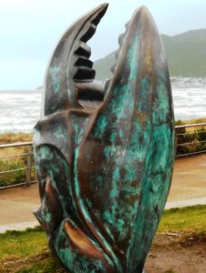 Local man Ned McKenzie has alas been found murdered in Northern Ireland’s seaside town of Newcastle. We recommend you start your murder trail at the Donard Car Park as his body was found dumped at the entrance, and evidence was also collected there. However, detectives think the murder was carried out elsewhere.
- The Newcastle Whodunit Hunt is a self-guided, walking murder mystery trail.
- On this route you will discover both historic sights and a collection of modern sculptures. You’ll hear of brandy smuggling and learn about the old granite mining industry and the history of this town which dates back 600 years! You’ll also read about an historic flight on the beach, the town’s railway connections, stories of ghosts, local myths & legends… and more!
- The clue route is approximately 2 miles, or about 3 km. It starts/ends at the coast road entrance of the Donard Park car park.
- The Whodunit Hunt booklet is packed with 28 clues to solve and LOADS of historical and tourist information to read.
 We suggest allowing at least two hours to solve this murder mystery, excluding any stops for refreshment.
- Accessibility – the route is generally fairly flat, with only moderate inclines.
- Refreshments – you’re spoilt for choice here with a large number of bars, cafes, coffee shops, restaurants, takeaways, and shops.
To pay using Paypal click here (or in the menu) to order this, or any other, Whodunit Hunt.
To purchase this Whodunit Hunt with credit / debit / Amex card please click here.
The starting point is shown in the map below, which is also where you should park if coming by car.
(c) 2023 – the term ‘Whodunit Hunt’, associated logo, website content, and all Hunt routes, ideas, images and photos, are protected by copyright. Any copying/distribution of anything embraced by our copyright is intellectual theft and therefore unlawful and illegal. Please respect the law as well as numerous years of our hard work.
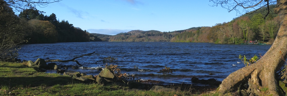
Who Killed Cathy In Castlewellan?
Cathy O’Reilly from Castlewellan has been murdered and detectives need your help to solve the mystery around her death. Her body was found dumped in Castlewellan lake but evidence tells us the murder was not committed here. The clue trail starts in the Lower Square of Castlewellan.
Note, we recommend completing this particular Whodunit Hunt by the end of October as some of the info signs at Castlewellan Forest park may then be changing.
 This Whodunit Hunt is a self-guided, walking murder mystery trail.
- On the clue route you will learn about the village’s history and some of the characters that were part of it, especially the Annesley family who designed the village layout and created what is now Castlewellan’s Forest Park. See historic buildings, read about the period when Castlewellan was connected to the railway system of Northern Ireland, enjoy the beauty of the forest park, even get a ghost story thrown in for good measure!
- The clue route is 2 ¼ miles / 3 ¾ km. The starting point is shown in the map below and the route ends in Castlewellan Forest Park near the lake.
- This Whodunit has 27 clues to solve in a booklet packed with extra historical and tourist information.
- The recommended time for this murder mystery is about two hours, excluding any stops for refreshment.
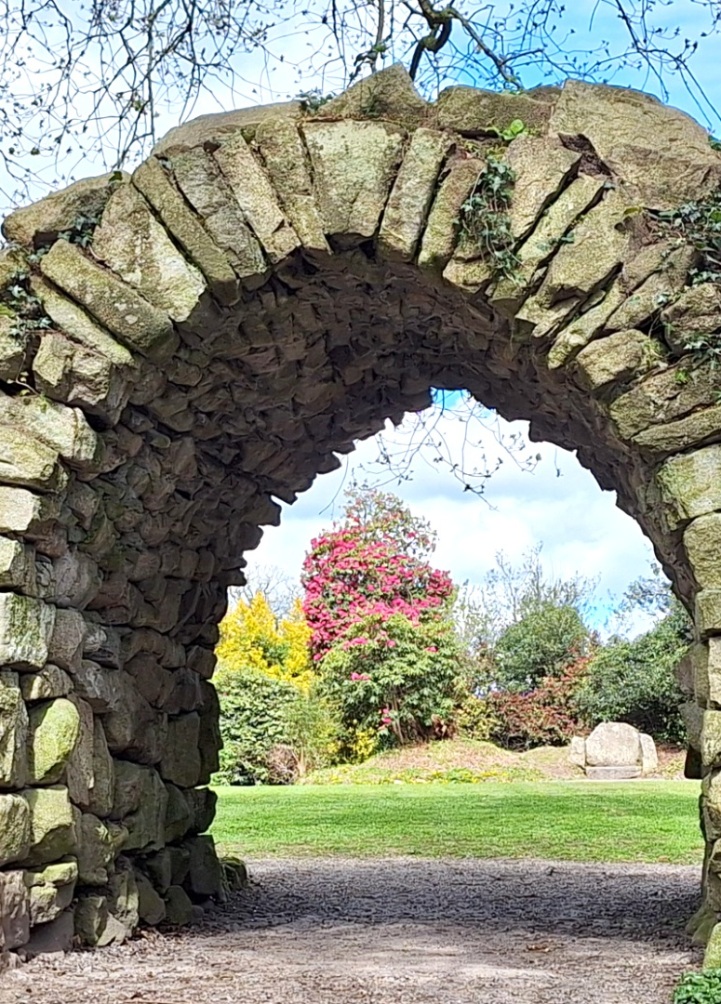
- You can extend your day here by spending time in the forest park (see below photo). There are many lovely walks in the park, as well as pretty gardens (which may still be closed on certain days due to rennovations).
- Accessibility – the route is generally fairly flat, but with one hill to partly descend and climb back up.
- Refreshments – there are a number of cafes, coffee shops, and restaurants here.
To pay using Paypal click here (or in the menu) to order this, or any other, Whodunit Hunt.
To purchase this Whodunit Hunt with credit / debit / Amex card please click here.
The starting point is at the car park beside the King’s Inn at Lower Square, shown in the map below.
(c) 2023 – the term ‘Whodunit Hunt’, associated logo, website content, and all Hunt routes, ideas, images and photos, are protected by copyright. Any copying/distribution of anything embraced by our copyright is intellectual theft and therefore unlawful and illegal. Please respect the law as well as numerous years of our hard work.
Who Slaughtered Sean in Saintfield?
Sean Magill has been sadly slain in the historical small town of Saintfield and our best investigators need your help to confirm their suspicions about the murder. Although his body was found at the ruins of the old windmill, we believe this was not where the murder was committed.
New version now available with several improvements and an extra clue added!
 The Saintfield Whodunit Hunt is a self-guided, walking murder mystery trail.
- Along the clue route you’ll see quite a number of old buildings in this quaint village, including the old coaching inn and several churches, as well as pretty flower displays. Learn about Saintfield’s turbulent history too – especially in the memorial garden – spanning hundreds of years.
- The clue route is 1 ¾ miles / 2 ¾ km. It starts/ends in the car park on Downpatrick Street which is signposted at a crossroads.
- This Whodunit Hunt has 28 clues and the booklet contains extra information not seen elsewhere in the village.
- The recommended time for this murder mystery is 1½ – 2 hours, excluding any stops for refreshment. The National Trust’s Rowallane Gardens is at the village outskirts nearby if you have time to extend your stay here.
 Accessibility – the route is generally fairly flat, with only moderate inclines.
- Refreshments – there are a number of cafes, coffee shops, convenience stores in Saintfield as well as the old White Horse Inn.
To pay using Paypal click here (or in the menu) to order this, or any other, Whodunit Hunt.
To purchase this Whodunit Hunt with credit / debit / Amex card please click here.
The starting point is the car park beyond the Masonic Hall on Downpatrick Street, shown in the map below.
(c) 2023 – the term ‘Whodunit Hunt’, associated logo, website content, and all Hunt routes, ideas, images and photos, are protected by copyright. Any copying/distribution of anything embraced by our copyright is intellectual theft and therefore unlawful and illegal. Please respect the law as well as numerous years of our hard work.
