Who Got Graham At Glenarm?
Graham Whelan has been found murdered in the village of Glenarm. Our chief detective has a heavy case load and needs your help to solve this murder mystery. Although Graham’s body was found in the harbour he certainly didn’t drown, says the coroner. So was he pushed… or murdered elsewhere? Only by following the evidence trail will all be revealed.
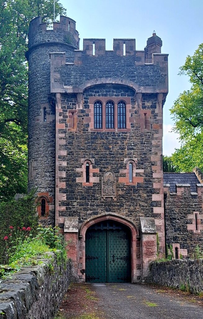 The Glenarm Whodunit Hunt is a self-guided murder mystery trail on foot.
- Explore the beautiful village of Glenarm, a conservation area with much history and quaint streets with preserved old shop fronts. Learn about the castle, characters who shaped the history of Glenarm, see historic buildings and beautiful coastal views.
- The clue route is almost 2 miles / 3 ¼ km long. It starts between the marina building and the nearby car park at the southern end of town.
- The Whodunit Hunt booklet is packed with over 30 clues to solve as well as several pieces of extra historical info and trivia not seen en route… and a folklore tale of heartbreak too!
- The recommended time for this murder mystery is a good two hours, excluding refreshment stops.
- Accessibility – most of the route is fairly flat, but towards the end there is a steep hill to ascend and then a shallower one to descend… but the climb is worth it for fabulous views!
To purchase this Whodunit Hunt with credit / debit / Amex card please click here.
To pay using Paypal click here (or in the menu) to order this, or any other, Whodunit Hunt.

The starting point is close to the red blob in the map below, with parking between it and the main road:

(c) 2023 – the term ‘Whodunit Hunt’, associated logo, website content, and all Whodunit Hunt routes, ideas, photos, are all protected by copyright. Any copying, impersonation or distribution of anything embraced by our copyright is intellectual theft and therefore unlawful and illegal. Please respect the law as well as all of our hard work.
Who Killed Kevin From Kingscourt?
Kevin King from Kingscourt has been found murdered and our chief investigator needs your help to solve the crime. Although his body was found at Bailieborough square, we think he may have been murdered elsewhere. So the trail for clues starts at Kingscourt, where he lived.
 This Whodunit Hunt is a self-guided, driving murder mystery trail. It starts at Kingscourt and ends at the unique tin church of Laragh.
- The Ancient East Churches trail visits a variety of historic spots in Counties Cavan and Monaghan. See beautiful churches, enjoy a lovely forest walk, explore the main street of Ballybay, learn about historic Bailieborough town and an ancient fair, see beautiful lakes, an unusual statue of an elk… and more!
- We’ve squeezed nearly 30 clues into this trail with lots of historical information added to the Whodunit booklet so that you get to know just a little more about the places you’re visiting.
- The route is 78 km (almost 49 miles).
- The total walking distance spread across all of the clue stops is 5 ¾ km / 3 ½ miles. This includes a lovely woodland walk of 2 ½ km / 1 ½ miles at Bailieborough Demesne – if you wanted to use up two of your clue helps instead of walking this distance you could do this if you wished… though in the spring the bluebells are beautiful here.
- We suggest allowing 4-5 hours to complete this Whodunit Hunt, excluding extended refreshment stops…. so it’s great for a wee day out.
- Accessibility – once out of the car the terrain is fairly flat, with mostly moderate slopes. Reasonable mobility is required to do the forest walk. Alternative routes can be found around steps.

To purchase this Whodunit Hunt with credit / debit / Amex card please click here and type AE Churches in the ‘Special Requests’ field at the start of the purchase page.
To pay using Paypal click here (or in the menu) to order this, or any other, Whodunit Hunt.
The starting point is at the church in Kingscourt shown below:

(c) 2023 – the term ‘Whodunit Hunt’, associated logo, website content, and all Hunt routes, ideas, images and photos, are protected by copyright. Any copying/distribution of anything embraced by our copyright is intellectual theft and therefore unlawful and illegal. Please respect the law as well as numerous years of our hard work.
Who Massacred Bill From Ballymoney?
Bill Malarkey from Ballymoney has been found dead in the town and we need your help to confirm suspicions about the murder. Although his body was found at the railway station, we suspect that the murder occurred elsewhere and recommend you start your trail for clues at the Dunlop Memorial Garden.
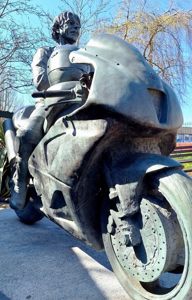 The Ballymoney Whodunit Hunt is a self-guided murder mystery trail on foot.
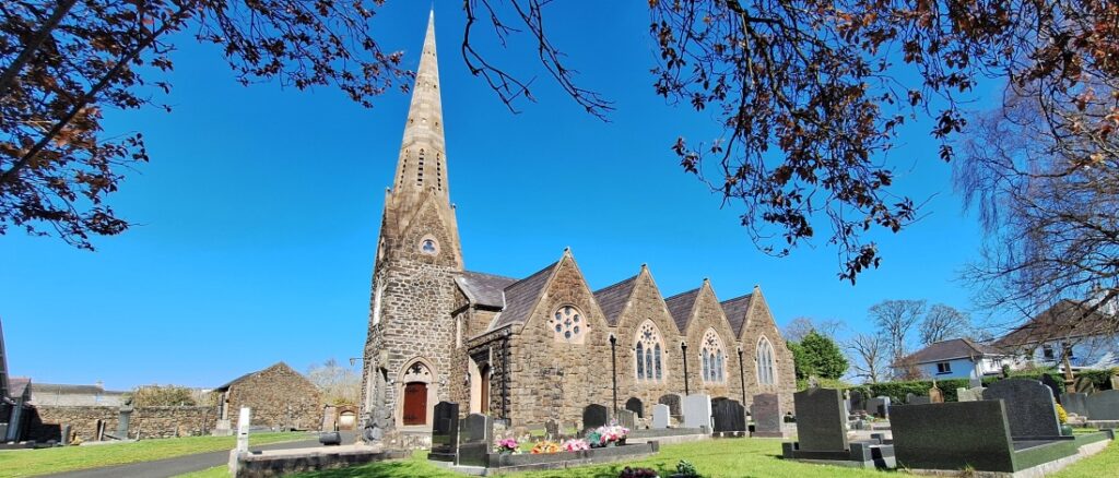
- You’ll especially love our Ballymoney Whodunit Hunt if you’re a biker as this is where the famous Dunlop racing family are from! You’ll start at the Dunlop memorial garden, and also see other sites associated with the family in the town. There are several historic buildings to see along the clue route too, including beautiful churches like the one below and the magnificent town hall. Read extra historical info in our booklet as well as tales of a ghost!
- The short clue route is almost 1 ½ miles / 2 ½ km. It starts at the Dunlop Memorial Garden and ends nearby – see map below.
- This Whodunit booklet is packed with over 25 clues to solve as well as several pieces of extra historical info and trivia not seen en route… including a ghost story!
- The recommended time for this murder mystery is 1 ½ – 2 hours, excluding refreshment stops.
- Accessibility – the route is generally fairly flat, with no steps.
To purchase this Whodunit Hunt with credit / debit / Amex card please click here.
To pay using Paypal click here (or in the menu) to order this, or any other, Whodunit Hunt.

(c) 2023 – the term ‘Whodunit Hunt’, associated logo, website content, and all Whodunit Hunt routes, ideas, photos, are all protected by copyright. Any copying, impersonation or distribution of anything embraced by our copyright is intellectual theft and therefore unlawful and illegal. Please respect the law as well as all of our hard work.
Who Wrecked Randalstown Ray’s Life?
Ray Campbell has been found dead at the base of the old railway viaduct, but the autopsy suggests that he was killed before being thrown off the bridge. However, with a large number of cases to solve, detectives need your help to conclude this case.
New launch for March 2025!
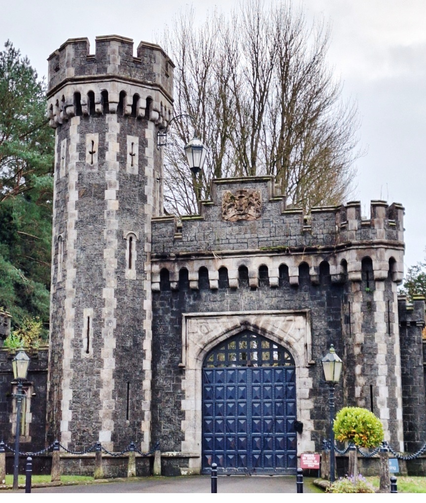 This Whodunit Hunt is a self-guided murder mystery trail on foot.
- Randalstown is a small town with a huge amount of heritage so you’ll see loads of historic sites on our figure-of-eight walk here that takes you over the railway viaduct! See an unusually shaped church, the viaduct of course and the ancient road bridge, the gate lodge to Shane’s Castle, learn about the history of its buildings and the mill here, nearby Game Of Thrones filming locations… and more!
- The clue route is almost 1 ½ miles, or about 2 ½ km.
- This Whodunit booklet is packed with 33 clues to solve (the most we’ve ever squeezed into a walking Whodunit) and several pieces of extra historical information and trivia not seen en route.
- Allow a full two hours to solve this murder mystery, excluding refreshment stops.
- Accessibility – the route is generally fairly flat, with only moderate inclines and no steps.

To pay using Paypal click here (or in the menu) to order this, or any other, Whodunit Hunt.
To purchase this Whodunit Hunt with credit / debit / Amex card please click here.
The starting point and car park is shown in the map below:

(c) 2023 – the term ‘Whodunit Hunt’, associated logo, website content, and all Hunt routes, ideas, photos, are all protected by copyright. Any copying, impersonation or distribution of anything embraced by our copyright is intellectual theft and therefore unlawful and illegal. Please respect the law as well as all of our hard work.
Who Bumped Off Brian In Ballymena?
Brian McCarthy has alas been found murdered in Ballymena. Our chief detective is struggling to conclude the case and needs your help to solve this murder mystery. The evidence trail starts near the Museum/Arts Centre building, on Bridge Street, where Brian used to work.
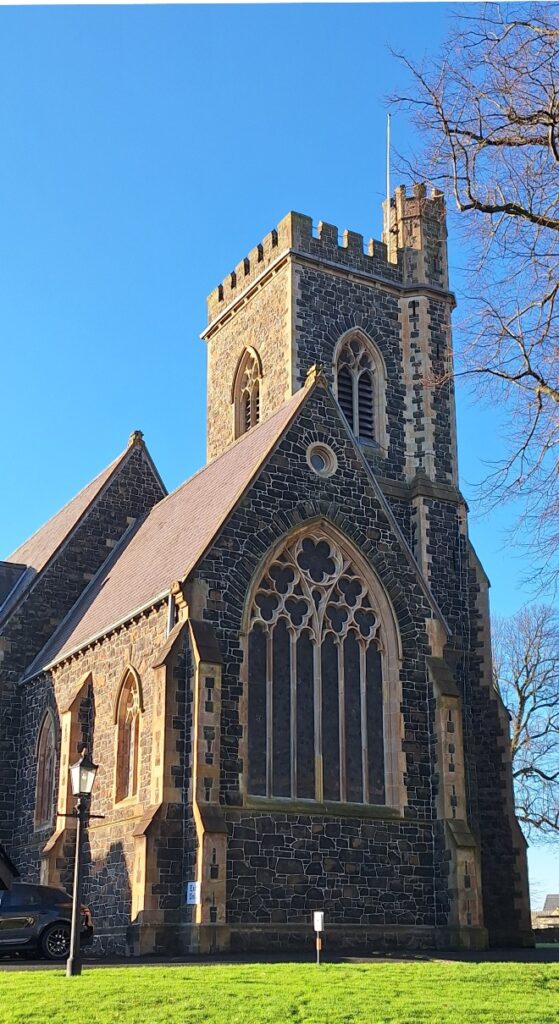 The Ballymena Whodunit Hunt is a self-guided murder mystery trail on foot.
- Investigate Ballymena closely and one finds quite a number of historic places, even if the original Ballymena castle is no more, as it began life as a town around 400 years ago. You’ll see many historic buildings (especially ones with beautiful Georgian architecture on Ballymoney Road), old churches, Ballymena’s very own Pentagon, learn about the history of its shops and markets, read ghost stories… and more!
- The clue route is almost 1 ½ miles, or about 2 ½ km. It starts/ends at the Mid-Ulster Museum/Arts Centre.
- This Whodunit booklet is packed with 28 clues to solve and several pieces of extra historical information not seen en route.
- The recommended time for this murder mystery is about 2 hours, excluding refreshment stops.
- Accessibility – the route is generally fairly flat, with only moderate inclines.
To purchase this Whodunit Hunt with credit / debit / Amex card please click here.
To pay using Paypal click here to order this, or any other, Whodunit Hunt.

(c) 2023 – the term ‘Whodunit Hunt’, associated logo, website content, and all Whodunit Hunt routes, ideas, photos, are all protected by copyright. Any copying, impersonation or distribution of anything embraced by our copyright is intellectual theft and therefore unlawful and illegal. Please respect the law as well as all of our hard work.
Who Fatally Hurt Harry In Holywood?
Harry Woods has alas been found murdered in Holywood, North Down, and our over-worked investigator needs your help to bring the case to a close. We recommend you start your search for clues at Holywood’s historic priory, as his body was found there; however, detectives think the body was left there to confuse us and believe the murder was carried out elsewhere.
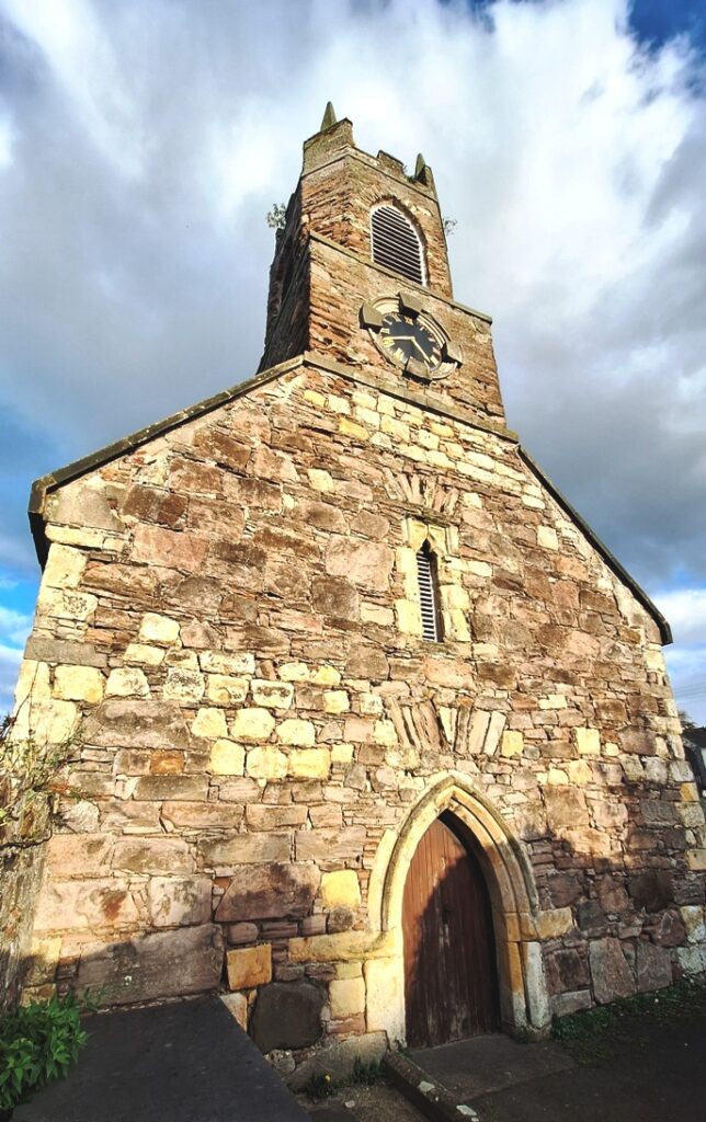 The Holywood Whodunit Hunt is a self-guided, walking murder mystery trail.
- Much of Holywood is designated a conservation area, preserving the grand 19th Century architecture that resulted from wealthy industrialists and merchants moving here after the railway opened in 1848. Along the clue trail you’ll come across quite a number of historic buildings, including of course the ruined priory; the only maypole on the island of Ireland is here too!
- The route is only 1¼ miles, or about 2 km, and fairly flat too, so perfect for those who don’t want to walk so much. The clue trail starts/ends at the priory (see map below).
- The Whodunit Hunt booklet is packed with nearly 30 clues to solve as well as several pieces of extra historical information.
- The recommended time for this murder mystery is 1½ – 2 hours. Extend your visit here with a refreshment stop at one of Holywood’s great coffee shops, cafes, or restaurants.
- Accessibility – this is a generally quite flat route, although some streets have moderate inclines.
To pay using Paypal click here (or in the menu) to order this, or any other, Whodunit Hunt.
To purchase this Whodunit Hunt with credit / debit / Amex card please click here.
(c) 2023 – the term ‘Whodunit Hunt’, associated logo, website content, and all Hunt routes, ideas, images and photos, are protected by copyright. Any copying/distribution of anything embraced by our copyright is intellectual theft and therefore unlawful and illegal. Please respect the law as well as numerous years of our hard work.
Who Bumped Off Ben From Bawnboy?
Ben McKeown from Bawnboy has been found murdered and our best investigators are struggling to conclude the case and thus need your help to solve the murder. Although his body was found in the Ballinamore Canal, it’s obvious to detectives that he was murdered elsewhere.
 The linear Cavan Lakeland Whodunit Hunt trail starts in outer Cavan and ends in Bawnboy.
- Enjoy beautiful lakeland scenery while visiting some fantastic historic sites! See an impressive castle and Drumlane abbey, an old folly with a beautiful paranomic view, a ruined church, and solve clues at and around the canal at Ballyconnell. You’ll also visit several historic places in and around Bawnboy including the neolithic Creggin stone, the grim Workhouse with its eye-opening history… and more!
- 28 clues to solve plus super sleuth clues to spot!
- The route is 66 km / 42 miles, while the total walking distance across all of the clues is 4½ km / 2¾ miles. This includes a there-and-back walk of 1¼ km to Flemings Folly for one clue, which you could avoid by using one of your clue helps… though you’d miss out on a lovely view.
- The recommended time for this murder mystery, excluding refreshment stops and return journey, is 4-5 hours.
- Accessibility – it is generally flat where the clues are to be found apart from the Flemings Folly walk that has moderate inclines; there are no steps that must be navigated.
To purchase this Whodunit Hunt with credit / debit / Amex card please click here and type Cavan Lakelands in the ‘Special Requests’ field at the start of the purchase page.
To pay using Paypal click here (or in the menu) to order this, or any other, Whodunit Hunt.

The starting point is in outer-Cavan on the R212 Dublin Road at a car park just to the north of Green Lough in the map below:

(c) 2023 – the term ‘Whodunit Hunt’, associated logo, website content, and all Hunt routes, ideas, photos, are all protected by copyright. Any copying, impersonation or distribution of anything embraced by our copyright is intellectual theft and therefore unlawful and illegal. Please respect the law as well as all of our hard work.
Who Liquidated Laura In The Lower Lough Erne Area?
Laura Irvine’s body has been found at the shore of Lower Lough Erne but a post mortem confirmed that drowning wasn’t the cause of death. Our investigators have uncovered much evidence but are struggling to tie it all together and thus need your help to solve the murder.
RECENT LAUNCH (23rd September)!
 The Lower Lough Erne Whodunit Hunt starts at Trory Jetty and ends at the outskirts of Enniskillen. It is a self-guided, driving murder mystery trail with a near-circular route.
- Enjoy beautiful lakeside scenery while visiting a plethora of historic places! You’ll see neolithic sites including a stone circle and strange carved figures, numerous castles, a famine grave, historic sites related to World War II… and more!
- Almost 30 clues to solve!
- The driving route is 77 miles / 123 km, with clues spread all around the Lough area; 13 miles of this route is along Lough Shore Road between clue stops at Belleek and Tully Castle. There is about 2¼ miles / 3¾ km of walking in total.
- The recommended time for this murder mystery, excluding refreshment stops and return journey, is about 5 hours.
- Accessibility – it is generally flat where the clues are to be found, with no steps that must be navigated.
To pay using Paypal click here (or in the menu) to order this, or any other, Whodunit Hunt.
To purchase this Whodunit Hunt with credit / debit / Amex card please click here.

The starting point is at Trory Jetty on the lower east shore of the Lough, shown in the map below:

(c) 2023 – the term ‘Whodunit Hunt’, associated logo, website content, and all Hunt routes, ideas, photos, are all protected by copyright. Any copying, impersonation or distribution of anything embraced by our copyright is intellectual theft and therefore unlawful and illegal. Please respect the law as well as all of our hard work.
Who Destroyed Deirdre In Derry?
Deirdre Moore has been found murdered in the historic walled city of Derry and we desperately need your help to solve the murder. Although the remains of Deirdre’s body were found near the Guildhall, we believe this was not where the murder was committed. The trail starts on the other side of the Peace Bridge, near where Deirdre lived.
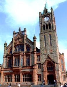 The Derry City Whodunit Hunt is a self-guided, walking murder mystery trail.
- Discover a wealth of history in this unique place, one of the best preserved walled cities in all of Europe! You’ll cross the Peace Bridge, visit the Guildhall with its impressive pipe organ, and then explore much of the city walls (and beyond) to see numerous historic and varied sites. You’ll see the cathedral, huge cannons, grand architecture, read ghost stories… and more!
- This Whodunit Hunt is jam-packed with over 30 clues to solve! The booklet also contains several pieces of extra historical and tourist information.
- There are a number of guided tours around Derry (usually in groups with a guide), and all have their merits. However, if you want a really affordable self-guided tour with a murder mystery theme that you can do at your own pace then we think ours is hard to beat! Our Whodunit trail even takes you to historic places beyond the city walls and packs in a plethora of varied sights in the city! We don’t dwell on the history of ‘The Troubles’, though – we wanted to keep our trail a bit more light-hearted.
- The recommended time for this murder mystery is about 3 hours, excluding refreshment stops.
- Accessibility – we don’t feel this particular Whodunit Hunt is suitable for people with mobility issues owing to steps to navigate and inclines for some clues.
To pay using Paypal click here (or in the menu) to order this, or any other, Whodunit Hunt.
To purchase this Whodunit Hunt with credit / debit / Amex card please click here.

The starting point is on the south side of the river beside the Bakery Ebrington, shown in the map below, with free parking nearby. The route ends near the Guildhall.

(c) 2023 – the term ‘Whodunit Hunt’, associated logo, website content, and all Hunt routes, ideas, images and photos, are protected by copyright. Any copying/distribution of anything embraced by our copyright is intellectual theft and therefore unlawful and illegal. Please respect the law as well as numerous years of our hard work.
Who Decimated Dolly in Dromore?
Dolly Moore has been found murdered in the historic market town Dromore and our best team of investigators are struggling to conclude the case and thus need your help to solve the murder.
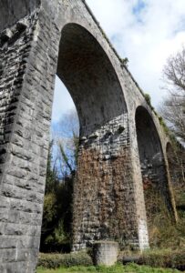 The Dromore Whodunit Hunt is a self-guided, walking murder mystery trail.
- Learn about the surprising amount of history that this former market town has to offer, which dates back over 800 years! You’ll learn about its railway history and see the impressive railway viaduct up close, read about famous inventor Harry Ferguson who was born nearby, see the cathedral and remains of an ancient Irish cross… and much more.
- The route is a moderate 1 ¾ miles, or about 2 ¾ km.
- The recommended time for this murder mystery, excluding refreshment stops, is around two hours.
- Accessibility – this is a mostly quite flat route, with just 2-3 steps to one clue.
- Refreshments – there are restaurants, cafes, and convenience stores along the clue trail.
To pay using Paypal click here (or in the menu) to order this, or any other, Whodunit Hunt.
To purchase this Whodunit Hunt with credit / debit / Amex card please click here.
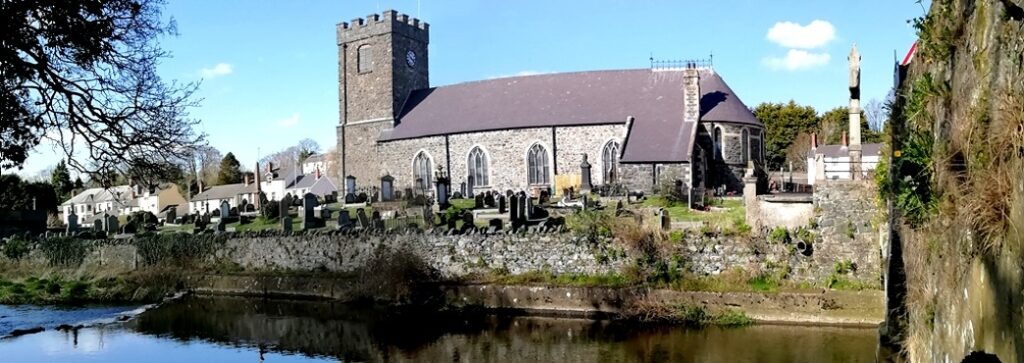
The hunt for clues starts/ends at Dromore Park, shown below:

(c) 2023 – the term ‘Whodunit Hunt’, associated logo, website content, and all Hunt routes, ideas, images and photos, are protected by copyright. Any copying/distribution of anything embraced by our copyright is intellectual theft and therefore unlawful and illegal. Please respect the law as well as numerous years of our hard work.
 The Glenarm Whodunit Hunt is a self-guided murder mystery trail on foot.


 This Whodunit Hunt is a self-guided, driving murder mystery trail. It starts at Kingscourt and ends at the unique tin church of Laragh.
 The Ballymoney Whodunit Hunt is a self-guided murder mystery trail on foot.
 This Whodunit Hunt is a self-guided murder mystery trail on foot.
 The Ballymena Whodunit Hunt is a self-guided murder mystery trail on foot.
 The Holywood Whodunit Hunt is a self-guided, walking murder mystery trail.
 The linear Cavan Lakeland Whodunit Hunt trail starts in outer Cavan and ends in Bawnboy.
 The Lower Lough Erne Whodunit Hunt starts at Trory Jetty and ends at the outskirts of Enniskillen. It is a self-guided, driving murder mystery trail with a near-circular route.
 The Derry City Whodunit Hunt is a self-guided, walking murder mystery trail.
 The Dromore Whodunit Hunt is a self-guided, walking murder mystery trail.