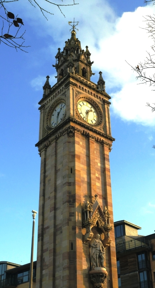
Who Squished Quinn At Queens?
Quinn O’Neill has been found murdered at Queens University and detectives need your help to solve the case. Although Quinn’s body was found at the foot of the Lanyon building tower, crime scene investigators confirm he didn’t fall and was left there to confuse us. The fact that he was enjoying his studies at Queen’s indicates foul play. But where was he killed? Follow the clue trail to solve the case.
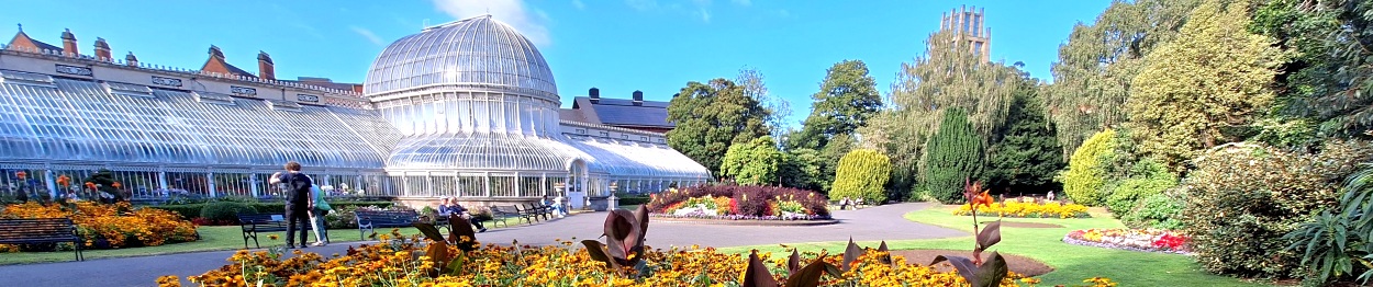
 The Queen’s Quarter Whodunit Hunt is a self-guided, walking murder mystery trail in Belfast.
- Along the clue route discover a wealth of history with impressive architecture in many buildings that you pass, especially around the university. Learn about the development of this area (which wasn’t even part of Belfast in the 1800’s) and characters who shaped it in prior generations, follow in the footsteps of a king… and more! If time allows, visit beautiful Botanic Gardens towards the end of your clue hunt too.
- The clue route is less than 2 miles (3 km).
- Whodunit Hunt booklet packed with over 30 clues to solve in a booklet containing several pieces of extra historical info.
- The recommended time for this murder mystery is 2-3 hours.
- Accessibility – fairly flat route, with one moderate hill.
- Refreshments – there are many tempting restaurants, cafes, and coffee shops along the route, especially on Botanic Avenue.
To purchase this Whodunit Hunt with credit / debit / Amex card please click here.
To pay using Paypal click here (or in the menu) to order this, or any other, Whodunit Hunt.
The starting point is at the central gates in front of the Lanyon building, shown in the map below:

(c) 2023 – the term ‘Whodunit Hunt’, associated logo, website content, and all Hunt routes, ideas, images and photos, are protected by copyright. Any copying/distribution of anything embraced by our copyright is intellectual theft and therefore unlawful and illegal. Please respect the law as well as numerous years of our hard work.
Who Took Katie’s Cookies?
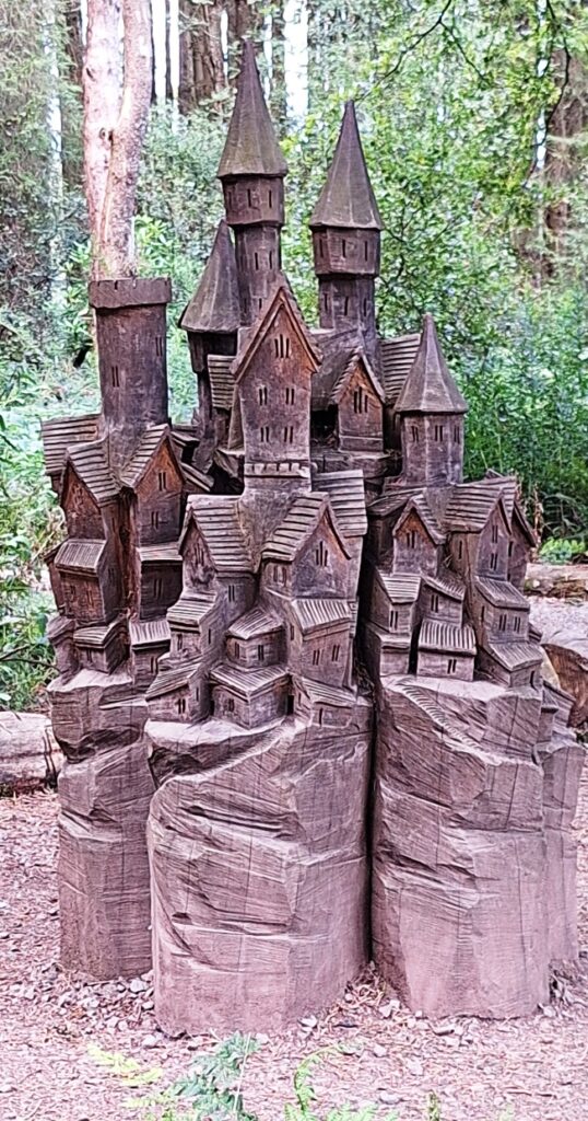
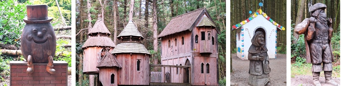
It’s well known that magic folk like sweet treats, especially cookies. Alas some of the magic folk in Pomeroy Forest are a bit naughty and one of them has run off with some of Katie’s freshly baked cookies that she was delivering to the forest cafe! Katie is so upset she can’t even remember what flavour cookies are missing. So we need your help to solve the mystery of the missing cookies!
JUST LAUNCHED!
 This Whodunit Hunt is a self-guided magical mystery trail on foot for families with young childen.
- Explore Pomeroy Forest Park in mid Ulster and search for clues to solve the mystery of the missing cookies. Follow the trail of fairy tales to read both well known stories and also discover local ones too, both of which provide clues to solve this mystery. See stunning wood carvings and enjoy assorted playparks.
- The clue route is approx 1.3 miles / 2 km long and this forest park is free to enter and park at.
- Whodunit Hunt booklet packed with 17 clues to solve as well as a snippet of trivia about the forest too! We’ll help you with two clues by email if you get stuck.
- Incredible value for a family at only £3.99 for a trail booklet… and definitely something different to do! Some clues might even help your young kids to count!
- The recommended time for this mystery trail is 1 ½ hours… depending upon how much energy your kids have at the playpark areas!
- Accessibility – the paths and clue route are generally flat, and great if you have a pram for a tiny tot!
To purchase this Whodunit Hunt with credit / debit / Amex card please click here.
Or to pay using Paypal click here.
The location of the forest is shown in the map below:

(c) 2023 – the term ‘Whodunit Hunt’, associated logo, website content, and all Whodunit Hunt routes, ideas, photos, are all protected by copyright. Any copying, impersonation or distribution of anything embraced by our copyright is intellectual theft and therefore unlawful and illegal. Please respect the law as well as all of our hard work.
Who Fatally Assaulted Alan From Antrim?
Alan Meekin has been found murdered at Belfast Castle and our best but overworked investigator needs your help to solve the case. It is believed that Alan was likely murdered elsewhere and so the hunt for clues starts at Waterworks Park in Belfast.
 The Antrim Castles Whodunit Hunt starts in North Belfast and ends at Antrim.
- This is a self-guided, driving murder mystery trail.
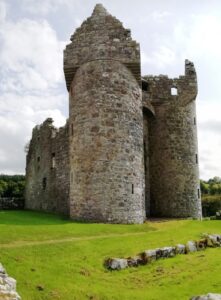
- Visit historic sites and beautiful gardens as you try and nail the criminal for this case. See Belfast and Antrim castles and pass another castle en-route (hence the trail name), beautiful gardens, Northern Ireland’s very own White House, mills, various historic sites in Antrim… and more!
- Over 30 clues to solve squeezed into a Whodunit booklet that has extra historical and tourist pointers!
- The driving route is only 26 miles, or 42km, from the start to the end point! There is about 2¾ miles / 4½ km of walking in total spread across all of the clues.
- The recommended time for this murder mystery from start to end points, excluding extened refreshment stops, is 4-5 hours.
- Accessibility – it is generally fairly flat where all of the clues are to be found.
To pay using Paypal click here (or in the menu) to order this, or any other, Whodunit Hunt.
To purchase this Whodunit Hunt with credit / debit / Amex card please click here.

The starting point is at the playground entrance to Waterworks Park, North Belfast, close to the point we’ve marked on the map below:
(c) 2023 – the term ‘Whodunit Hunt’, associated logo, website content, and all Hunt routes, ideas, photos, are all protected by copyright. Any copying, impersonation or distribution of anything embraced by our copyright is intellectual theft and therefore unlawful and illegal. Please respect the law as well as all of our hard work.
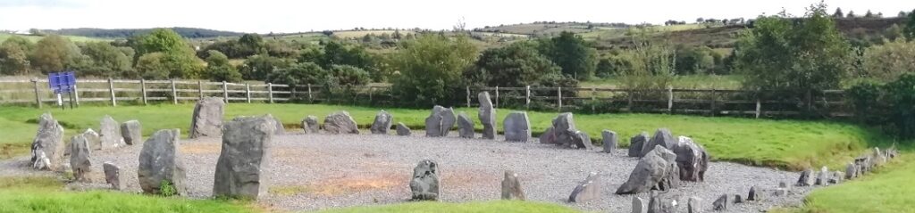
Who Liquidated Laura In The Lower Lough Erne Area?
Laura Irvine’s body has been found at the shore of Lower Lough Erne but a post mortem confirmed that drowning wasn’t the cause of death. Our investigators have uncovered much evidence but are struggling to tie it all together and thus need your help to solve the murder.
 The Lower Lough Erne Whodunit Hunt starts at Trory Jetty and ends at the outskirts of Enniskillen. It is a self-guided, driving murder mystery trail with a near-circular route.
- Enjoy beautiful lakeside scenery while visiting a plethora of historic places! You’ll see neolithic sites including a stone circle and strange carved figures, numerous castles, a famine grave, historic sites related to World War II… and more!
- Almost 30 clues to solve!
- The driving route is 77 miles / 123 km, with clues spread all around the Lough area; 13 miles of this route is along Lough Shore Road between clue stops at Belleek and Tully Castle. There is about 2¼ miles / 3¾ km of walking in total.
- The recommended time for this murder mystery, excluding refreshment stops and return journey, is about 5 hours.
- Accessibility – it is generally flat where the clues are to be found, with no steps that must be navigated.
To purchase this Whodunit Hunt with credit / debit / Amex card please click here.
To pay using Paypal click here (or in the menu) to order this, or any other, Whodunit Hunt.
The starting point is at Trory Jetty on the lower east shore of the Lough, shown in the map below:
(c) 2023 – the term ‘Whodunit Hunt’, associated logo, website content, and all Hunt routes, ideas, photos, are all protected by copyright. Any copying, impersonation or distribution of anything embraced by our copyright is intellectual theft and therefore unlawful and illegal. Please respect the law as well as all of our hard work.
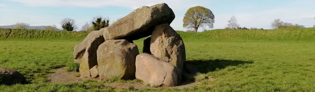
Who Bludgeoned Oisin From Belfast?
Oisin White has been found murdered at Shaw’s Bridge in Outer Belfast and our best but overworked investigator needs your help to solve the case. Oisin’s body was found at Shaw’s Bridge, but we believe he was killed elsewhere. The clue trail starts at Drum Bridge car park, see where the evidence trail leads you…
 This is a self-guided, linear driving Whodunit Hunt, starting near Drumbeg and ending in Belfast.
- On your clue hunt you’ll see historic houses and gardens, an ancient burial tomb, the site of an American military cemetery, visit a historic waterway and the land of Narnia… and more!
- The driving route is only 20 miles / 31 km long with nearly 30 clues to solve! There is nearly 2 ¾ / 4 ¼ km of walking in total.
- It is recommended to allow 4-5 hours to solve this murder mystery, excluding refreshment stops.
- Accessibility – there are no steps to navigate but moderate inclines.
- There are assorted places for refreshment; we like the Lockkeeper’s Cottage, especially in spring/summer for alfresco eats.
To pay using Paypal click here (or in the menu) to order this, or any other, Whodunit Hunt.
To purchase this Whodunit Hunt with credit / debit / Amex card please click here.
The starting point is shown in the map below.
(c) 2023 – the term ‘Whodunit Hunt’, associated logo, website content, and all Hunt routes, ideas, photos, are all protected by copyright. Any copying, impersonation or distribution of anything embraced by our copyright is intellectual theft and therefore unlawful and illegal. Please respect the law as well as all of our hard work.
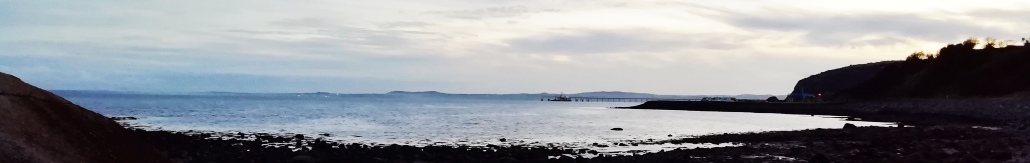
Who Whacked William in Whitehead?
William White has been found murdered in the old coastal town of Whitehead and our investigators have uncovered very few leads. Therefore, we desperately need your help to solve the murder. Although William’s body was found on the beach, our detective team believe this was not where the murder was committed.
 The Whitehead Whodunit Hunt is a self-guided, walking murder mystery trail.
- Along the clue route you will discover many interesting sights, both historic and modern, in this quaint seaside village. Learn about its railway history, the evolution of its tourism industry, and several of the characters who shaped it. See a castle, read about a pop star who used to live in Whitehead… and someone who made their home in a cave!
- The clue route around Whitehead is almost 2 ½ miles, or about 4 km. It starts/ends in the car park at the end of the Old Castle Road.
- The Whodunit Hunt booklet is packed with 30 clues as well as several pieces of historical and tourism trivia.
- The recommended time for this murder mystery is two hours, excluding any stops for refreshment.
- Accessibility – the route is generally fairly flat, with only moderate inclines. Previous sleuths attempting this trail report that it is ‘dog-friendly’!
- Refreshments – there are a number of cafes, coffee shops, and convenience stores in Whitehead.
To pay using Paypal click here (or in the menu) to order this, or any other, Whodunit Hunt.
To purchase this Whodunit Hunt with credit / debit / Amex card please click here.
The starting point is shown in the map below.
(c) 2023 – the term ‘Whodunit Hunt’, associated logo, website content, and all Whodunit Hunt routes, ideas, photos, are all protected by copyright. Any copying, impersonation or distribution of anything embraced by our copyright is intellectual theft and therefore unlawful and illegal. Please respect the law as well as all of our hard work.
Who Bashed Belle In Belfast?
Belle Finch has been found murdered in the capital city of Belfast. Although her body was found outside the Ulster Hall, we believe this was not where the murder was committed and so the clue trail starts at City Hall. Detectives are struggling to reach a conclusion to the case and need your help to solve the murder.
 The Belfast City Centre Whodunit Hunt is a self-guided, walking murder mystery trail.
- Along the clue route you will discover a wealth of history, with architectural splendour in many of the city buildings. You’ll learn about the maritime and linen industries, see major tourist attractions both old and new, come across some of the characters who shaped the city in prior generations… and much more!
- The route is approximately 1 ¾ miles / 2 ¾ km, and starts at City Hall.
- This Whodunit Hunt is packed with over 30 clues to solve in a booklet containing several pieces of extra historical and tourist information. One clue is even linked to a famous detective!
- The recommended time for this murder mystery is about 3 hours, excluding any stops for refreshment or retail therapy!
- Accessibility – this is a flat route, and any steps can be avoided using ramped floors (primarily in Victoria Centre).
- Refreshments – there are almost countless restaurants and cafes, some great coffee shops, large stores with their own food / beverage options, and convenience stores on your clue hunt.
To purchase this Whodunit Hunt with credit / debit / Amex card please click here.
To pay using Paypal click here (or in the menu) to order this, or any other, Whodunit Hunt.
The starting point is in front of City Hall, shown in the map below:
(c) 2023 – the term ‘Whodunit Hunt’, associated logo, website content, and all Hunt routes, ideas, images and photos, are protected by copyright. Any copying/distribution of anything embraced by our copyright is intellectual theft and therefore unlawful and illegal. Please respect the law as well as numerous years of our hard work.
 Walking Whodunit Hunts are single-location murder mystery trails where you explore a village or an area of a town or city in search of clues to solve a crime. All have much history to uncover, show you grand and impressive architecture, and many reveal surprising facts about both places and the people that shaped them!
The places listed below (by county) all have single-location walking murder mystery trails for you to solve. Click any location link for more detail. Map available at the bottom of the page to locate trails in a particular area too.
 In County Antrim are Ballymena, Ballymoney, Carrickfergus, Lisburn, Randalstown and Whitehead Whodunits… and we now have a new one in Glenarm!
- On the North Antrim coast our Ballycastle and Portrush walking Whodunit Hunts have just been launched!
- In Belfast itself are Belfast City Centre and Titanic Quarter trails, as well as our new Europa taster trail if you’re short on time… and now our brand new Queen’s Quarter Trail around the university area.
- Armagh City, Loughgall, and Lurgan trails in County Armagh.
- Belturbet and Cavan Town in County Cavan.
- In County Derry are trails at Derry and former market town Moneymore.
- Just launched is the Donegal town Whodunit Hunt!
- In County Down you’re spoilt for choice! There are walking Whodunits in Banbridge, Castlewellan, Dromore, Moira, Newcastle, Newry as well as nearby Derrymore Estate, Rathfriland and Saintfield … and if you’re short on time try our new Newry Taster Trail! And we’ve just launched a walking Whodunit hunt at Royal Hillsborough.
 In North Down are trails at Bangor and Holywood, and a brand new taster trail at Newtownards!
- In County Fermanagh is the Enniskillen Whodunit Hunt.
- Ardee, Drogheda, Dromiskin and Dundalk trails available in County Louth.
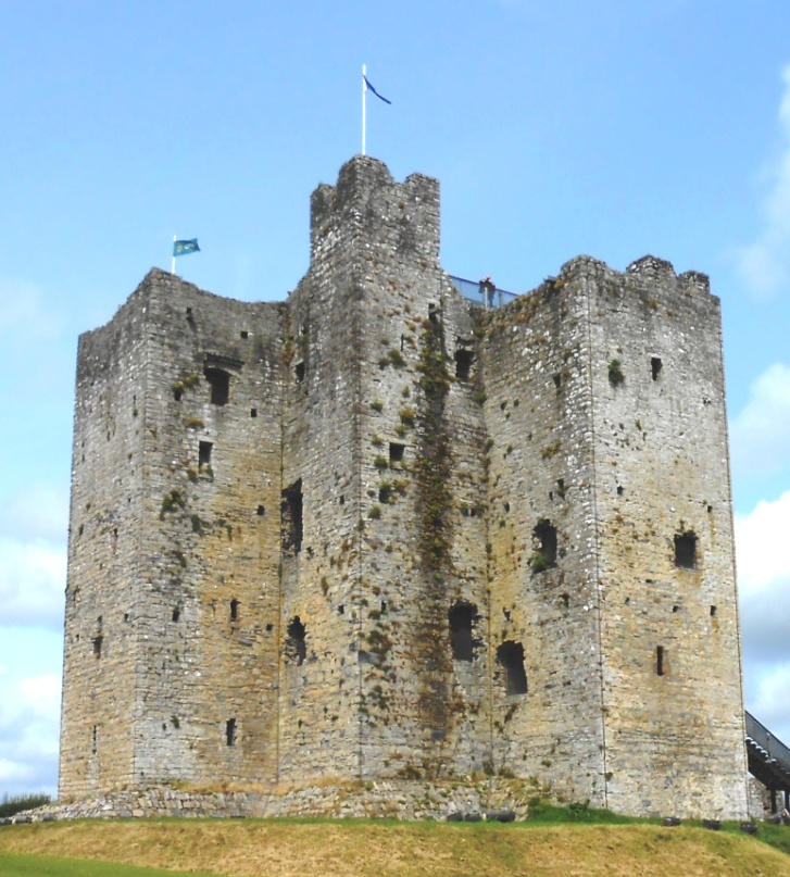
- Kells, Navan and Trim in County Meath.
- Castleblaney, Clones, Glaslough and Monaghan trails in County Monaghan.
- In County Sligo is our new Sligo Town walking trail.
- In County Tyrone you can find walking Whodunits for Caledon, Omagh, and our brand new launch at Dungannon.
There are more walking Whodunit Hunts in the pipeline too, including Galway City, Kilkenny, and a very unique trail in Dublin!
 The vast majority of Whodunit Hunt clues are accessible by those with prams and wheelchair users, as we’ve determined routes for evidence investigation with as few steps as possible. Check the applicable Whodunit Hunt page(s) for full details, which indicate any accessability issues.
The map below shows all of our murder mystery trails, as well as our new kids trails. Walking murder mystery trails available are indicated by a black walker/runner symbol. Kids trails are indicated by a yellow star. Pipeline walking Whodunits are blue – if you’re interested in one of these then please contact us and we’ll tell you when they’re available.
Use the card or Paypal link in the page of whichever Whodunit Hunt you are interested in to purchase it.
(c) 2023 – the term ‘Whodunit Hunt’, associated logo, website content, and all Whodunit Hunt routes, ideas, photos, are all protected by copyright. Any copying, impersonation or distribution of anything embraced by our copyright is intellectual theft and therefore unlawful and illegal. Please respect the law as well as all of our hard work.
